Need a drone pilot anywhere in the world?
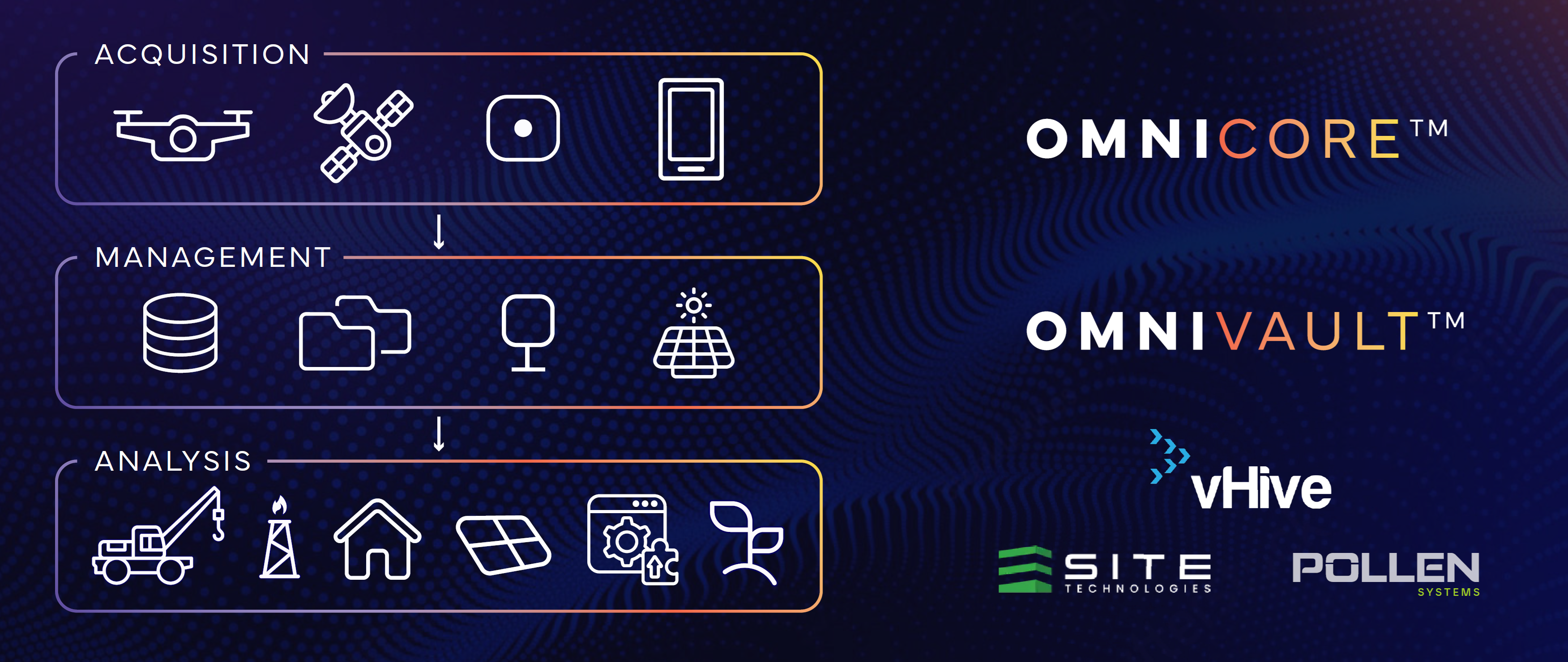
Omniris helps organizations coordinate global drone pilot operations, capture aerial data, process orthomosaics and 3D models, and deliver AI-ready geospatial intelligence for construction, utilities, telecom, mining, agriculture, insurance, energy, infrastructure, and property teams worldwide.
Field: global pilot coordination, flight capture, imagery, GPS, LiDAR, thermal, NIR
Cloud: processing, indexing, analytics, secure delivery, GIS publishing
From “I need a drone pilot” to decision-ready geospatial data.
Drone pilots available through the Omniris global pilot network.
Distributed pilot coordination across regions, countries, and enterprise operating environments.
Orthomosaics, point clouds, 3D models, RGB, NIR, thermal, and derived layers.
Outputs delivered into ArcGIS, MapLibre, dashboards, reports, and partner systems.
Hire drone pilots for mapping, inspections, monitoring, and aerial data capture anywhere your work happens.
Drone Mapping Services
Capture high-resolution aerial imagery for orthomosaics, site maps, terrain models, construction progress, asset inventories, and change detection.
Drone Inspection Services
Coordinate pilots for infrastructure, utilities, telecom towers, roofs, solar farms, property assets, industrial facilities, and hard-to-reach environments.
Enterprise Drone Programs
Combine pilot operations with governed upload, secure storage, role-based access, audit trails, repeatable workflows, and GIS-ready publishing.
Request. Capture. Process. Publish.
Request Coverage
Tell us where, when, and what you need captured: acreage, asset type, flight requirements, deliverables, deadlines, compliance needs, and regional constraints.
Coordinate Pilots
Omniris helps coordinate qualified drone pilots and capture teams for field mapping, inspections, progress tracking, and repeat site monitoring.
Process the Data
Convert raw drone imagery into orthomosaics, 3D models, point clouds, maps, indices, reports, and structured geospatial artifacts.
Deliver Intelligence
Publish governed outputs into OmniVault, ArcGIS, MapLibre, dashboards, reports, partner systems, and AI-ready data workflows.
Drone pilots and geospatial workflows for industries that can’t afford uncertainty.
Construction Drone Services
Site surveys, weekly progress capture, earthworks, as-built validation, safety documentation, and change tracking.
Utility Drone Inspection
Powerline corridors, substations, vegetation encroachment, storm response, compliance documentation, and asset monitoring.
Telecom Tower Inspections
Tower inspections, equipment audits, line-of-sight modeling, site documentation, and rollout planning.
Mining Drone Mapping
Stockpile volumes, haul roads, pit monitoring, site security, environmental monitoring, and change detection.
Agricultural Drone Imaging
Crop health, irrigation checks, NDVI/NDRE, NIR, thermal imaging, field scouting, and seasonal monitoring.
Insurance & Property
Claims validation, roof inspections, pre/post-disaster imagery, building audits, and property condition reports.
Solar & Energy Assets
Solar farm inspection, thermal anomaly detection, site documentation, asset monitoring, and recurring capture programs.
From local inspections to international geospatial programs.
Global Pilot Coordination
Coordinate drone capture teams across regions, countries, customers, sites, and enterprise operating units.
Sovereign Deployment Models
Support cloud, hybrid, and on-premise deployment patterns for customers with data residency, performance, security, or regulatory requirements.
Enterprise GIS Integration
Publish governed outputs into ArcGIS, MapLibre, analytics tools, dashboards, partner systems, and operational workflows globally.
Most drone projects fail after capture. Omniris handles the workflow after the flight.
Not just “a pilot with a drone”
Drone capture is only the beginning. Omniris connects field operations to processing, QA/QC, storage, metadata, governance, and delivery.
Searchable project history
Index sites, jobs, locations, pilots, timestamps, sensors, flight outputs, and derived products so your team can find the right artifact quickly.
Enterprise-grade delivery
Publish data into ArcGIS, MapLibre, dashboards, partner systems, and AI workflows instead of leaving valuable imagery scattered across folders and hard drives.
The governed geospatial data vault behind the global pilot network.
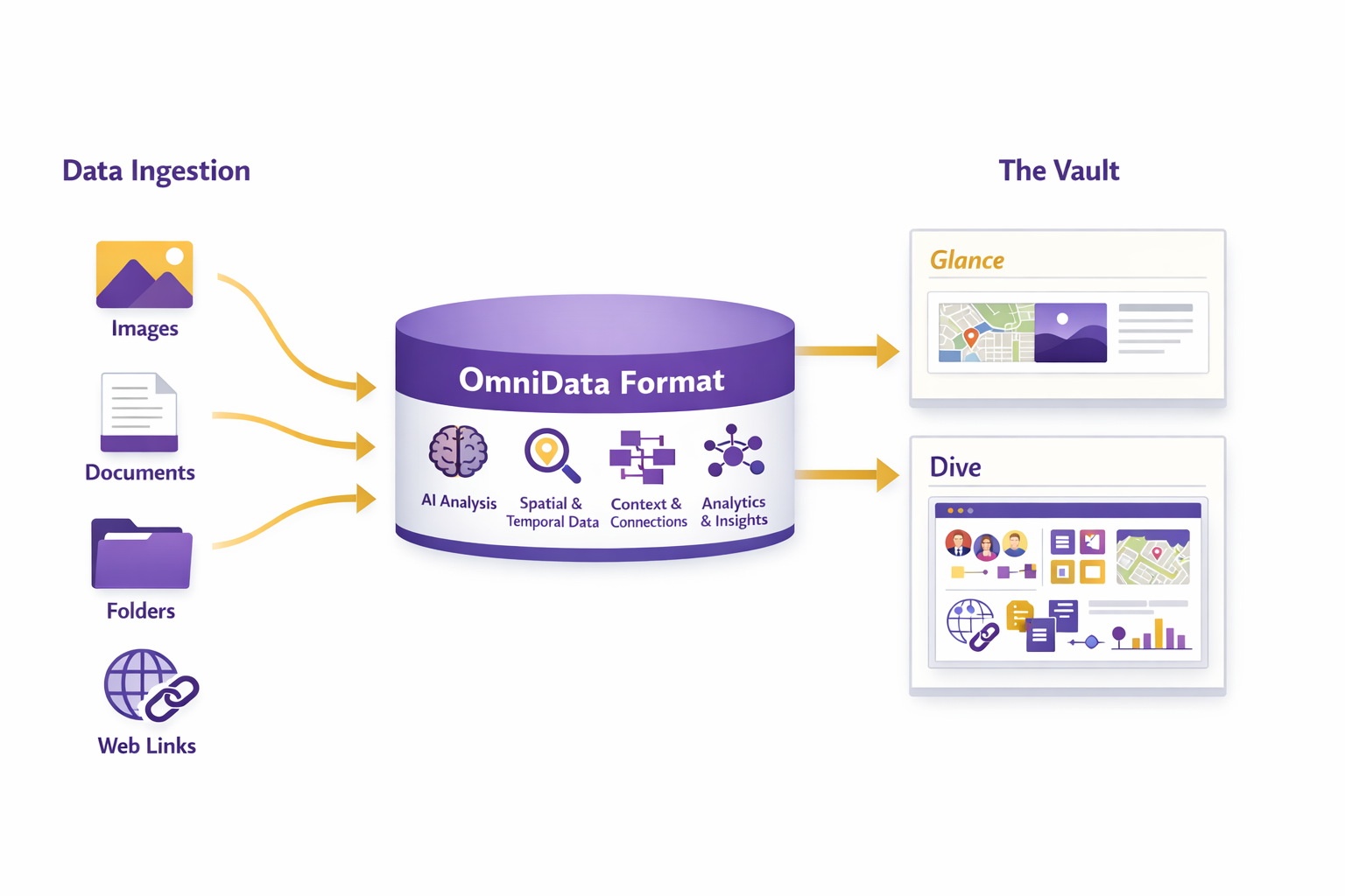
Ingest
Bring in drone, satellite, mobile, IoT, LiDAR, thermal, RGB, NIR, annotations, and field data from distributed capture teams.
Structure
Normalize metadata, organize artifacts, preserve lineage, apply role-based access, and make projects discoverable across teams.
Publish
Deliver layers, maps, tiles, models, analytics, reports, and operational outputs into the systems where decisions actually happen.
Built for enterprise drone programs, GIS teams, and AI-ready geospatial data.
ArcGIS & MapLibre Publishing
Publish layers, features, tiles, and geospatial outputs into ArcGIS, MapLibre, dashboards, customer systems, and partner workflows.
AWS, Azure, or On-Premise
Deploy in modern cloud environments or on-premise for performance, sovereignty, redundancy, and regulated enterprise requirements.
AI-Ready Data
Convert raw field capture into structured time-series datasets for computer vision, change detection, analytics, and future automation.
From drone pilot coordination to governed geospatial intelligence.
- Capture: Drone pilots, satellites, mobile teams, IoT, LiDAR, thermal, RGB, NIR, voice notes, GPS, and field annotations.
- Process: Orthomosaics, 3D models, point clouds, derived indices, reports, maps, QA/QC, and metadata normalization.
- Vault: Store, index, search, govern, audit, secure, and manage geospatial artifacts across teams, partners, projects, and time.
- Publish: Deliver outputs into ArcGIS, MapLibre, APIs, dashboards, analytics apps, reports, and partner systems.
Capture • Process • Index • Deliver
Capture
Collect RGB, NIR, thermal, LiDAR, GPS, site notes, and field context.
Process
Generate orthomosaics, point clouds, 3D outputs, indices, reports, and derived products.
Index
Organize by project, location, date, sensor, pilot, asset, output type, and workflow.
Deliver
Publish into ArcGIS, MapLibre, dashboards, reports, APIs, and enterprise data systems.
Turn drone imagery into a clean, navigable operating model.
OmniData turns “a pile of drone files” into an operational geospatial system: structured artifacts, consistent naming, durable metadata, lineage, access control, and clear delivery paths from field capture to published intelligence.
- One place for raw imagery, processed outputs, analytics, reports, and deliverables.
- Fast discovery by location, time, sensor, job, asset, and derived product.
- Governance with RBAC, auditability, and repeatable workflows for teams and partners.
Need a drone pilot, aerial inspection, or global geospatial data workflow?
Email sales@omniris.world • Call (425) 503-1693