Your geospatial intelligence system of record.
Omniris turns drone, satellite, and IoT streams into a searchable, governed vault—then delivers analysis-ready layers back into ArcGIS and partner systems with enterprise speed and control.
Offline/Field: imagery, annotations, GPS, voice notes, LiDAR
Cloud: AI/ML processing, indexing, analytics, publishing
Go from raw capture to decision-grade GIS—without losing control.
A vault you can trust
Centralize imagery, sensor streams, annotations, and derived products with consistent metadata, access control, and repeatable workflows.
Search at enterprise speed
Index everything—jobs, locations, timestamps, sensors, and outputs—so teams can find the right artifact in seconds, not hours.
Publish where work happens
Deliver layers and services into ArcGIS and partner systems for dashboards, reporting, and operational decision workflows.
Esri-native. Cloud-ready. Built to scale across organizations.
Built on Esri ArcGIS
Native integration for layers, features, publishing, and map services—on a proven enterprise GIS foundation.
Azure, AWS, or On-Premise
Deploy in Azure or AWS today. On-prem is available for performance, sovereignty, and redundancy.
Field to Cloud
Offline capture for teams in the field; cloud AI/ML processing for analytics, enrichment, and publishing.
Partner-built modules across industries that can’t afford uncertainty.
Construction
Site surveys, structural inspection, earthworks, progress tracking.
Agriculture
Crop health (NDVI/NDRE), irrigation checks, thermal and NIR insights.
Mining
Stockpile volume, haul-road monitoring, change detection over time.
Utilities
Asset monitoring, vegetation encroachment, compliance documentation.
Telecom
Tower inspections, line-of-sight modeling, 5G rollout planning.
Insurance
Claims validation, pre/post-disaster imaging, fraud detection.
Property
Building audits, equipment inspection, aerial 3D visualization.
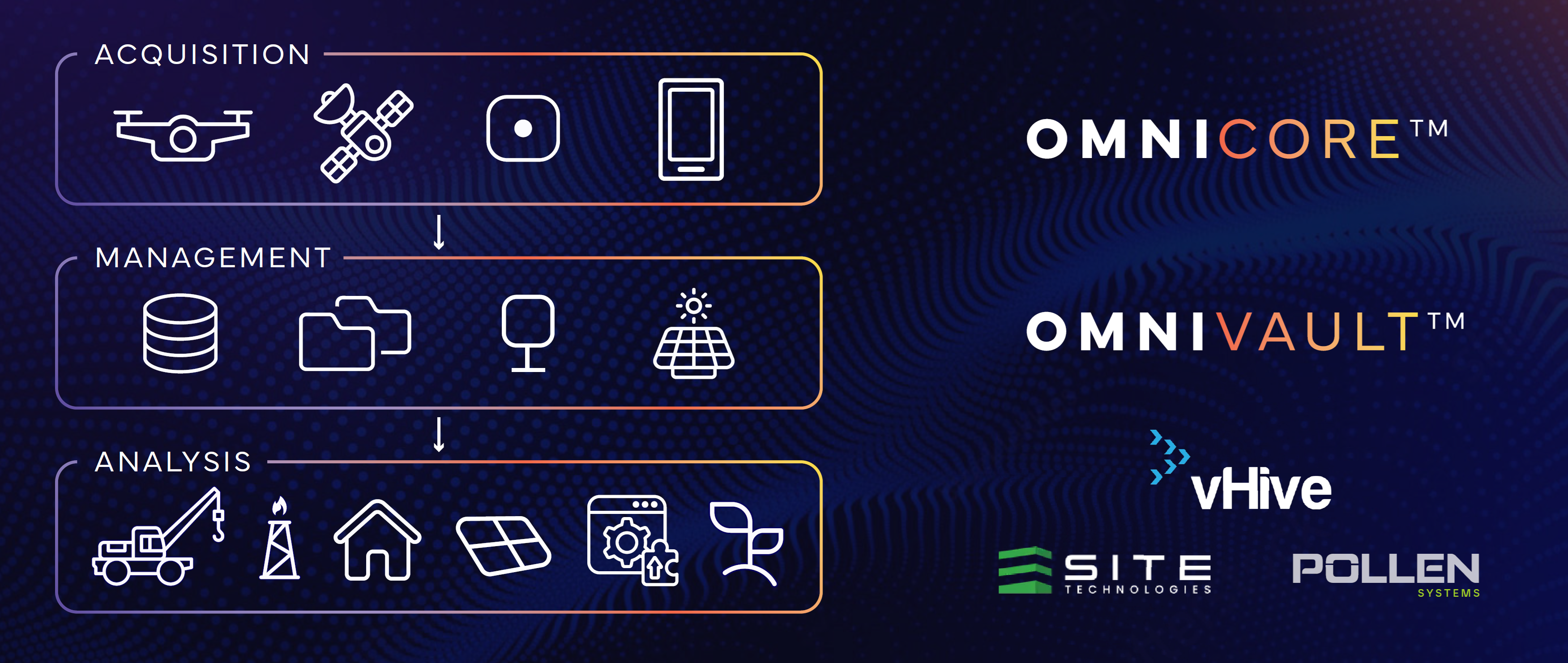
From acquisition → management → analysis → action.
- OmniVault coordinates acquisition workflows from drones, satellites, mobile teams, and IoT—handling ingest, synchronization, authentication, and job/task routing across environments.
- OmniVault stores, indexes, and catalogs imagery, sensor streams, annotations, and derived products—supporting fast search, metadata normalization, version control, and enterprise RBAC.
- Publishing & Partner Systems consume outputs via APIs and GIS services—powering analytics apps, dashboards, reporting, and decision workflows.
Capture • Normalize • Enrich • Publish
Capture
Bring RGB, NIR, Thermal, LiDAR, and ground truth into the Vault.
Normalize
Georeference, mosaic, standardize metadata, and prep for analytics.
Enrich
Run models, NDVI/NDRE, thermal maps, change detection, and more.
Publish
Serve layers and tiles into ArcGIS and partner systems for action.
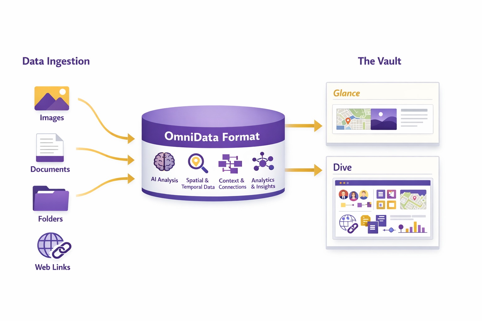
A clean, navigable data model your teams can actually operate.
OmniData is how Omniris turns “a pile of files” into an operational, governed system: structured artifacts, consistent naming, durable metadata, and clear lineage from raw capture to published outputs.
- One place to find every artifact: raw, processed, analytics, reports, and deliverables.
- Fast discovery via indexing: location, time, sensor, job, and derived products.
- Governance with RBAC, auditability, and repeatable workflows for teams and partners.
Ready to put your geospatial data to work?
Email sales@omniris.world • Call (425) 503-1693